| |
| |
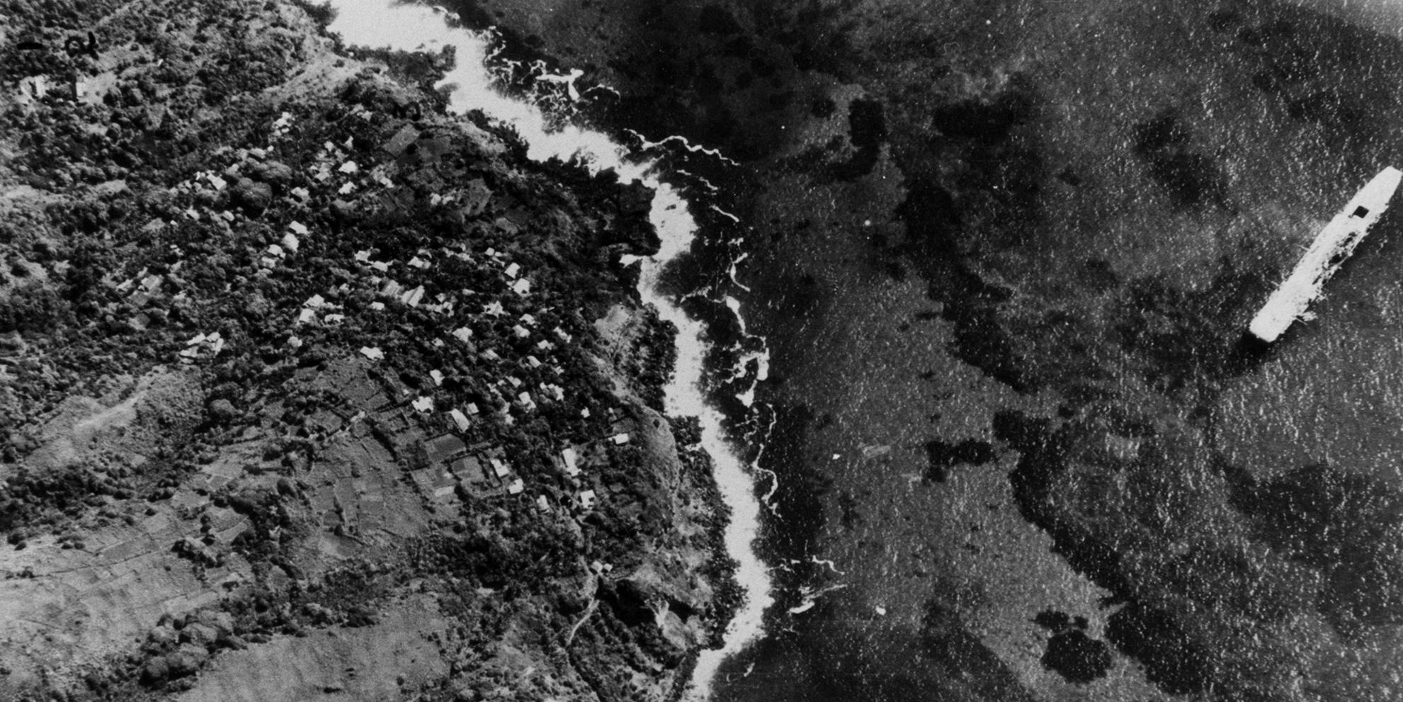
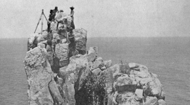
Image of the Month: Among the tens of thousands new images released on Air Photo Finder this month are 32 of the remote Pitcairn Islands. Most of these were taken from helicopters flown off HMS Warrior, a Royal Navy aircraft carrier on its way back to the United Kingdom after participating in the Operation Grapple nuclear tests at Malden Island and Kiritimati. At the right of this image, Warrior is moored at Pitcairn Island’s Bounty Bay, with the capital Adamstown visible on the shore. The visit marked the first time any aircraft had landed on Pitcairn, as island dignitaries were ferried to and from the vessel via helicopter.
HMS Warrior was commissioned in 1942, but did not see any active service during the Second World War. After a period on loan to the Royal Canadian Navy, Warrior served with the Royal Navy from 1948 to 1958, before being sold to the Argentine Navy, where she served as ARA Independencia until being scrapped in 1971.
Image credit: Collection: DOS, Sortie: WARRIOR/RN/57, Frame: 0002 (July-August 1957).
|
|
|
View Image in Air Photo Finder
|
|
|
|
This month, we have started uploading fresh batches of imagery to our Air Photo Finder. Keep checking back regularly to see new images, and we’ll be publishing comprehensive release notes for every batch soon.
Inspired by the new batch of imagery released on Air Photo Finder this month, the focus of August’s newsletter is the Directorate of Overseas Surveys (DOS) collection, and some of the highlights from it that can now be viewed on our online portal.
The surveyors of the Directorate of Overseas Surveys worked in challenging conditions all around the world. To start with, photography was largely taken by Royal Air Force (RAF) photographic reconnaissance squadrons, but from 1953 the DOS predominantly issued contracts to commercial aerial survey firms. However, they did not stop relying on military photography altogether.
Our Image of the Month of Pitcairn Island comes from a small but remarkable collection of photographs taken from helicopters launched by the HMS Warrior, on her way back to the United Kingdom from the Operation Grapple nuclear tests. Missions like these provided valuable imagery of some of the most remote British colonies and territories.
Elsewhere in this month’s newsletter, you can read more about the Directorate of Overseas Surveys on our website, expand your reading with the official history of the Directorate and dive into more of the newly released imagery on Air Photo Finder.
We hope you enjoy exploring this month’s newsletter!
Best wishes,
The NCAP Team
|
|
|
|
| |
 |
|
 |
| |
|
|
|
|
|
| Operation Dynamo - Evacuating Dunkirk |
The Directorate of Overseas Surveys Collection |
| |
|
| Images held by the National Collection of Aerial Photography show key locations in the Allied pocket around Dunkirk between 26 May and 4 June 1940, from where over 338,000 British, French and Belgian troops were evacuated in a military operation codenamed Operation Dynamo. |
Our Image of the Month this August comes from the Directorate of Overseas Surveys (DOS) collection. The collection contains c.1.7 million aerial photographs taken on behalf of the British government throughout the second half of the twentieth century, covering large parts of Africa, East Asia, and the islands of the Caribbean Sea, Atlantic and Pacific Oceans. |
| |
|
| Read More |
Find Out More |
| |
|
|
| |
 |
|
 |
| |
|
|
|
|
|
| Air Photo Finder Uploads |
Mapping the World: History of the Directorate of Overseas Surveys |
| |
|
| This month we are delighted to announce that we have started the process of uploading further imagery to our new online image portal. Included in this first batch of imagery is coverage of the Caribbean, as well as dramatic images of remote Atlantic islands such as Tristan da Cunha and South Georgia. |
Many of the images released this month on Air Photo Finder come from the Directorate of Overseas Surveys (DOS) collection at NCAP. Mapping the World provides a fascinating insight into the history and activities of the DOS, and is often available from second-hand booksellers. |
| |
|
| Explore |
Read |
| |
|
|
| |
GET INVOLVED |
|
| |
 |
|
 |
|
|
|
|
| |
| |
|
|
This email has been sent by Historic Environment Scotland. If you no longer wish to receive NCAP emails, you may unsubscribe.
This is an automated email. Please do not click reply. |
| |
| |
|
|
|
|
| |
| © Historic Environment Scotland - Scottish Charity No. SC045925 |
| |
| |
| |
Historic Environment Scotland
Longmore House
Salisbury Place
Edinburgh
EH9 1SH |
|
 |
|
| |
|
|